View of the North Atlantic in an antique globe, Smithsonian National Air and Space Museum, September 2010. This artifact is part of the "America by Air" exhibition. Juan Trippe, president of Pan Am Airlines, was accustomed to using this globe to calculate flight distances (using string!) and often posed with it in publicity photos (see here for more).
It's interesting to see how much borders and place-names have changed over time. Here, the Hawaiian Islands are called the "Sandwich Islands" (Cook named the islands in honor of the John Montagu, the 4th Earl of Sandwich -- who, contrary to popular belief, did not actually invent sandwiches).
Take a look at North America! Canada is called "British North America." And Alaska is "Russian America." And much of what's now the Western part of the US lacks any borders or writing.
Showing posts with label map. Show all posts
Tuesday, March 1, 2011
Thursday, October 21, 2010
Disorienting Braille Maps
Braille maps feature prominently in "America on the Move," an ongoing exhibition at the National Museum of American History). This map depicting streetcar paths in DC circa 1900 provides inscriptions in raised letters along with Braille dots. You can also use your fingers to trace the contours of the city and discern the routes streetcars could take as they moved people about the city. Note the standard map orientation here, with north as as "up."
This map depicting harbor travel in New York City in the 1920s is a little more complicated. It includes inscriptions and Braille dots on either side of the map, so that side that is "up" is not based on absolute cardinal directions - instead, what is "up" depends on how you are positioned in relation to the map.
(For related posts, click the "Braille" tag below or on the right hand side of this page.)
This map depicting harbor travel in New York City in the 1920s is a little more complicated. It includes inscriptions and Braille dots on either side of the map, so that side that is "up" is not based on absolute cardinal directions - instead, what is "up" depends on how you are positioned in relation to the map.
(For related posts, click the "Braille" tag below or on the right hand side of this page.)
Saturday, October 2, 2010
Nevada: "Official" or "Spanish" Pronunciation?
One of the items I brought back from the 2010 National Book Festival (see related post here) was this tourist map of Nevada. On its front and back flaps, it features a very curious mark over the first letter "a" in the word "Nevada." The mark directs its readers to pronounce the name of the state as "Nevada," using this [æ] sound, rather than "Ne-VAH-da," using this [ɑː] sound. Earlier this summer, some Nevada legislators discussed the idea of declaring the [æ] sound as the "official" pronunciation of the state's name. The implication here is that the "other" pronunciation of the state name, using the [ɑː] sound, is perceived as the "Spanish" pronunciation. (For a more detailed discussion of this issue, see here.)
In the context of this pronunciation debate, I find it curious that this tourist map readily acknowledges that the name of the state is Spanish in origin - it flatly states that "Nevada means 'snow-capped' in Spanish." So why would you go out of your way to discourage people from pronouncing it the "Spanish" way?
Wednesday, September 29, 2010
Creative Logo (Department of Transportation)
Today I spotted this logo on a construction vehicle as workers were repaving part of the street. The logo bears the DC flag, and below a lower-case "d" and a punctuation mark (period). District Department of Transportation = D-DOT. Get it? (This logo also appears on the D-DOT website.) Capitol Hill.
(For another use of the DC flag, see this license plate.)
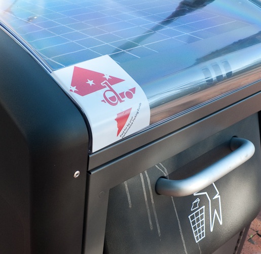
[Added Oct 1, 2010] Just noticed this brand new solar trash compactor (yes, this is what DC tax dollars pay for!) at Eastern Market. A snazzier version of the D-DOT logo superimposed upon a DC flag (colors reversed) and a map indicating the shape of the District.
(For another use of the DC flag, see this license plate.)
[Added Oct 1, 2010] Just noticed this brand new solar trash compactor (yes, this is what DC tax dollars pay for!) at Eastern Market. A snazzier version of the D-DOT logo superimposed upon a DC flag (colors reversed) and a map indicating the shape of the District.
Labels:
capitol hill,
flag,
government,
logo,
map,
semiotics,
technology,
transportation
Sunday, March 21, 2010
Latino Culture Night Poster
A few days ago I noticed this poster for an event celebrating the Latin American cultures. I find it interesting that the title of the event ("Noche de Cultura") is in Spanish, even if not all Latin American countries use Spanish. Perhaps there's some irony in the fact that an event with the theme "transcending borders" uses a visual motif that relies upon borders and national flags...or maybe the little red ribbons (mountains? hills?) are reaching across borders? I tend to over-read these things.
Saturday, January 30, 2010
Multilingual Map: Territorial Waters?
One last detail of this multilingual map. Here we see Florida and the Bahamas (with place-names in English, since the US and UK lay claim to these lands respectively) and Cuba's place-names are in Spanish. When it comes to the sea, English is used right up to the north coast of Cuba; everything south of Cuba is in Spanish.
The use of English or Spanish demarcates different parts of the sea, conceptually it dividing this contiguous body of water into distinct cultural/linguistic zones. The tidy distinction does break down, though; for instance, Jamaica's territory bears English place-names yet the water immediately around the island (presumably within Jamaica's jurisdiction) bears Spanish text. As a whole, the map really visualizes (for me) how arbitrary and paradoxical the notion of "territorial waters" is in the first place. In order to define "territorial water," one must first conceive of water as if it were land (Latin etymology: terra = earth, land).
For more on this map, see here and here.
Labels:
art,
culture,
government,
map,
multilingual,
spanish
Multilingual Map: Language and Territory
Another detail of an intriguing multilingual map. All the place-names on this map are written in the official language of the nation-state that lays claim to that land. I'm intrigued here by what happens to the sea. Could the Spanish-language "Golfo de México" imply that this entire body of water "belongs" to Mexico? I would assume that the US (or individual coastal states) must lay claim to jurisdiction over some of the part of the sea before it becomes "international waters" but I'm no expert in maritime law...
For more on this map, see here and here.
Labels:
art,
culture,
government,
map,
multilingual,
spanish
Multilingual Caribbean Map: Language and Place
This detail of a multilingual map (in the building where I work) shows two locations very much in the news: Cuba and Haiti. On the left, note "Guantánamo" (with diacritical mark over the A, since all of the Cuban place-names are rendered in Spanish). On the right, HAÏTI (with marks over the I, since all the Haitian place-names are in French). Curiously, the water "in between" these lands is marked neither in Spanish nor French. Instead, it gets an English name: "Windward Passage."
Not quite sure how to interpret the use of English for this particular body of water, but the map as a whole has an interesting way of visualizing the relationship between language and place.
For a larger view of the Caribbean Sea and (here designated in Spanish as "Mar Caribe"), click below.
For more on this map, see here and here.
Not quite sure how to interpret the use of English for this particular body of water, but the map as a whole has an interesting way of visualizing the relationship between language and place.
For a larger view of the Caribbean Sea and (here designated in Spanish as "Mar Caribe"), click below.
For more on this map, see here and here.
Labels:
art,
culture,
french,
government,
map,
multilingual,
spanish
Thursday, November 12, 2009
Invisible Braille Palimpsest
How do you navigate the Red or Green line if you're (color) blind or visually impaired? One map in the Metro Center station addresses this problem by superimposing Braille inscriptions on top of the "regular" map. Note the raised dots over the names of stations, and patterns of raised shapes to "translate" the color of each line.
Sunday, November 1, 2009
A Missing Language
Yesterday I took a trip to the National Gallery of Art. I noticed that the museum provides guide maps in seven languages including English and (L, front to back) French, Spanish, Italian, German, Japanese, and Mandarin Chinese. But the sign (R) only states that guides are available in six languages (i.e., Chinese is missing).
Was this sign produced before Chinese was added to the pantheon of guide map languages? Or is this discrepancy just another bureaucratic error?
Subscribe to:
Posts (Atom)